Hike to Vireo Lake
June 3, 2024
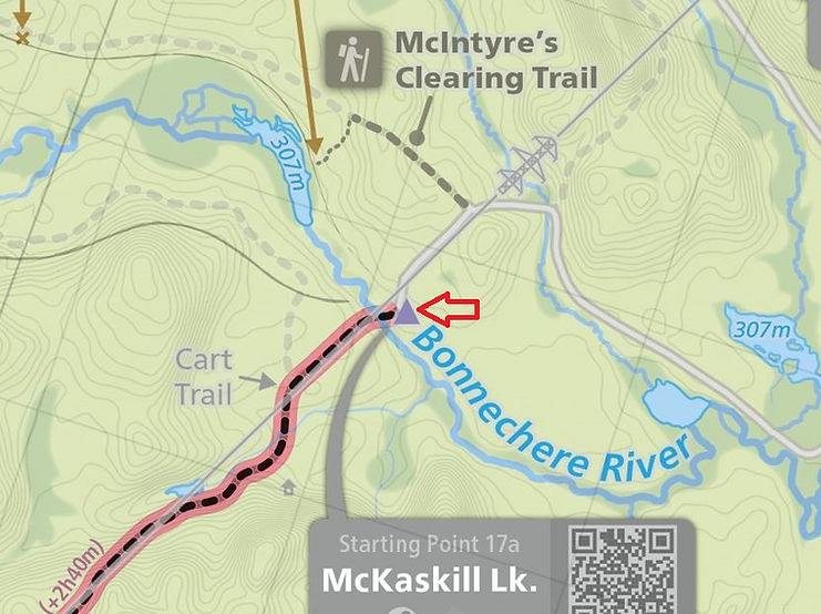
We had hiked in to Vireo several years ago using the portage trail from the hydro line, which brings you to the northwest arm of the lake. This time we decided to bushwhack to the northeast arm of the lake. The starting point was the bridge over the Bonnechere River along the hydro line. The sign before the bridge indicates only authorized vehicles are permitted beyond this point.
Driving in we saw a moose and a deer along the Basin Depot Road, as well as turkeys and rabbits. There were also numerous turtles on the go, and many signs of where they have been digging in the sand to lay eggs.

We would be hiking up the hydro line several kilometers along the route of the 10 km cart trail to McKaskill Lake. Our plan was to leave the cart trail at what in the past was referred to as the Vireo Lake trail or road.

Red arrow indicates starting point. Map courtesy of Maps by Jeff
After leaving the hydro line it was surprising to see how the Vireo Lake trail is now grown over with pine, hemlock and maple. Only three years ago we had used this trail to walk to Little Hogan Lake. At that time most of the trail was quite clear. Now, however, sections of the trail are completely grown over and hidden.

There is a series of ponds between the trail and Vireo. We planned to hike along these ponds, which would take us about half way to the lake. Beyond the ponds there is a ravine that runs toward the lake.

We used a series of 3 ponds to make our way toward Vireo.
Map courtesy of Fish On-Line.


In the areas around the ponds the mosquitos were wicked, and throughout the hike the deer flies were out for blood. It was slow going, taking about 1.5 hours to get across country to the lake. We came out at a shallow part of the lake along the northeast arm as planned.

Vireo Lake

In June of 2022 there was a forest fire on the penninsula on the far shore across from us but we could not see signs of the fire from this location.

With the flies swarming around us, we did not stay at the lake a long time. We followed the same route back to the trail.

This was an attempt to show in a photo how thick the mosquitos were but unfortunately it doesn't quite capture it.

Back to the hydro line with 4 km to go to reach the Bonnechere River. This was probably the hottest day of 2024 to date so we were carrying more fluid than usual.

Our route -- orange line. On the return we checked out the larger of the McGuire Lakes -- about 400 m off the Vireo Lake trail.

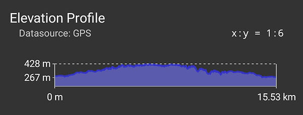
Duration: approx. 6 hrs. Distance: 15.5 km

The hike involves a steady climb from 267m at the Bonnechere River to a high point of 428m.